Ride with GPS Releases Offline Maps for iPhone and Android

Rick Youngblood

CarbonCraft Master
So I was out on a ride yesterday in the boonies and found myself without cell service, imagine that, scary huh!?! Pulled out my Android phone to map my location, no cell service = no map. Where am I, how far is the next town, what's up ahead?

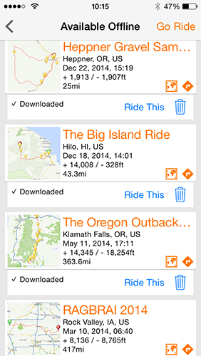
I remembered Ivan mentioned an offline GPS map app called MapMe. So I download it onto my phone, and also came across this "Ride with GPS Releases Offline Maps for iPhone and Android" while doing a Google search. You can download your routes onto you phone. It's part of their paid service. I will be back out into the boonies tomorrow and will try out MapMe app and RWGPS download map.

http://ridewithgps.com/news/offline_maps_release

iphone_offline_maps.png
 
Last edited:

1happyreader

zen/child method
Boonies

Hi Rick
Am visiting BigSky MT,,, and Maps.Me is sooo much better than google and my data feed in the hills.!!!

Ride with gps,,download your route early,, (I hate 2 wait)
Are you looking to conserve battery by turning off data and wifi, like in the RWGPS video ?

enjoy your ride !
 

Rick Youngblood

CarbonCraft Master
Tim, no not trying to

Tim, no not trying to conserve battery (I carry a portable charger) or phone cell service. I get out into areas that has no cell service, so I don't get Google live maps or any live maps from Strava or Ride with GPS and can't see where I'm at or what's up ahead.

But with the new download service from RWGPS, I can build my route at home (which I do quite often if I'm headed to an area I'm not familiar with), download it to my phone before leaving. Then pull up my route without the use of data or phone service. There are still quite a few areas around here with no cell service - hard to believe in this day and age.
 

Charles.Plager

Recumbent Quant
Google maps let's you cache

Google maps let's you cache the maps, too. You can also check our OSM apps (open source maps).
 

SamP

Guru
Another bike computer app

Another bike computer app with offline maps: IpBike
The user interface is a bit ugly (the author is working on a complete redesign) , but if you have ANT+ sensors on you and/or your bike and your phone has ANT+ support (last few generations of Samsung Galaxy and Sony phones do), you can display and record all kinds of ride data.
 

Ivan

Guru
Maps.Me uses OSM data -- just

Maps.Me uses OSM data -- just that Maps.Me makes the downloading super simple. I install it on the phones of visitors who come to my city, so they can walk and find their way back to my home or to wherever they are going. Not cycle specific of course, but very easy to use and free.

Did not know RideWithGPS had offline routing...
 

1happyreader

zen/child method
Off line maps not the reason.


The reason I tried RWGPS Ride was for the audible turn by turn directions on a charity ride in unfamiliar territory.

I am in my bifocal years and hate having to stop to get glasses and read a map

The program will also read whatever text you add to your cuesheet.

So for fun my test route ended with a comment, "Hal,, open the pod door Hal,, open the door"
 
My favorite ride planning ap is Footpath. It has run, cycle and drive specific routing, multiple mapping options including topo and it's by far the easiest tool I've found for charting a route on my IPhone. It also generates an interactive ride profile.
 

LarryOz

Cruzeum Curator & Sigma Wrangler
Great info.
I was just reading up on rwgps turn by turn availability. It looks really great from the youtube demos I saw.
I will heaving to Calvins Challenge in 3 weeks and their 50 miles loops looks like it has about 44 turns. Lots of reports of folks getting lost last year and previous.
I wish Strava or MMR had this feature. Looks like I'll have to subscribe to another premium service though for rwgps. I'll probably let Strava and MMP premiums fall by the wayside when the year is up though.
 

Eric Winn

Zen MBB Master
Great info.
I was just reading up on rwgps turn by turn availability. It looks really great from the youtube demos I saw...

I used the iOS version of the RWGPS app to ride my newly purchased Strada velomobile home from Whitehouse, Ohio to Brighton, Michigan - about 85 miles or so last August.

I used a route I had created ahead of time from my PC on my RWGPS account and it worked very well. I did have one hiccup where it somehow lost the history of my start but the routing and directions continued to work for the entire trip.

Oh and I missed a turn and the off course warning because I had turned the audio way down talking to my SAG while riding at one point and then forgot to turn it back up until after it dawned on me that I was off course (by quite a lot - I continued north on a dirt road for about 2-4 more miles than necessary instead of jogging over east about a mile to pick back up on a paved road). :rolleyes:

You may need to experiment with settings and get a feel for it before using it in a time sensitive environment like Calvins. I think I had the alert distance set too short and I overran a couple of them and had to loop back.

Distance for alerts options:
  • 50 meters
  • 100 meters
  • 150 meters
Navigation Toggles:
  • Overlay next Cue (show next cue over the map on approach)
  • Audio alert for Cues (emit beeps to announce the next turn)
  • Speak upcoming Cues (speak directions aloud on approach - this is really cool)
  • Warn when off-course (play warning tone when 50m off route)
 
Last edited:

ratz

Wielder of the Rubber Mallet
For the edge 1000 I am using RWGPS turn by turn too, the cues are better than Garmin connect and the custom warning distance is better than the default you get from Strava routes. So still the best game in town and worth premium cost
 
Last edited:

LarryOz

Cruzeum Curator & Sigma Wrangler
I just subscribed today (another monthly fee :eek:) and make a little test route and tried it in my car. Very nice. I have already loaded the Calvin's 50 and 7 miles loops as routes into my RWGPS data.
I had read reports from last year's Calvin's that many people got lost on the route. We'll with 44 some odd turns in the 50 mile loop I can believe it.
Check this out: http://ridewithgps.com/routes/55010

Very cool that you can download the maps and so you get them even without cell service.
 

Eric Winn

Zen MBB Master
I think Calvin's was the one that has had problems with a section being sabotaged with tacks a couple of times. If I'm remembering right be sure to be alert just in case...
 
Top